
All drones record their location with GPS to some degree of accuracy commensurate to the quality of onboard GPS. Higher accuracy systems refine the quality of the GPS solution with an RTK or PPK correction. In any case, the GPS observations are reported as ellipsoid heights. A geoid offset is required to convert the ellipsoid height from the GPS to orthometric height (elevation).
Ellipsoid height is the difference between the ellipsoid and a point on the Earth’s surface also known as geodetic height. This is the elevation reported by GPS receivers. An ellipsoid is a representation of the Earth’s surface that assumes the Earth is a smooth uniform sphere. Since this is not a true representation of the Earth’s surface a conversion must be performed to accurately capture elevation.
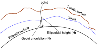
A geoid is more representative of the Earth’s surface as it takes into account the undulation and irregularities. Geoid models are very region specific, allowing for conversion from the ellipsoid to national vertical datums. Geoid height is the offset value between the geoid and ellipsoid model measured locally. The geoid offset is used to convert between ellipsoidal height and a local vertical datum.
Orthometric height is the distance between the point on the Earth’s surface and the geoid. Basically, its height below or above the Mean Sea Level (MSL) when extended onto land.
This is the height is typically used by surveyors or engineers who need accurate data.
In the US geoid height is a negative value with the exception of Alaska, where it’s a positive.
Since drone projects typically do not cover large areas applying a geoid offset can greatly improve your survey results. Fortunately, there are many online tools for determining the geoid offset for your project. The National Geodetic Survey (NGS) offers one which can be found via this link. Simply choose an image in the center of your project, record the Lat/Long and find the geoid offset for that location. Apply this offset to the altitude report in the EXIF of all images and proceed with your processing. Alternatively, your processing software may allow you to apply a geoid offset at project setup. This offset is then applied to all your image locations without you having to manually adjust all your EXIF data.
With RTK and PPK solutions that have had a geoid offset applied, you can then restrict your processing software from adjusting these values by selecting a direct georeferencing option when performing the bundle adjustment. However, since most drones capturing imagery do not have a highly accurate IMU, you will still want to allow your processing software the freedom to adjust for roll, pitch and, yaw.
Once your dataset is processed, compare to surveyed check points within your project. The results should be extremely accurate.

RELATED ARTICLES


