
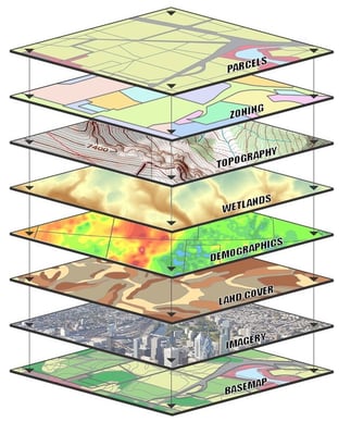
At the base of most geographic Information systems (GIS) is a geospatially enabled image. The accuracy or resolution of this image in part determines the positional accuracy and quality of all layers built or overlayed upon it. This is exactly why base data (imagery) is so vital in GIS. It is true that some GIS applications use a map as the base layers, but again that map likely came from geospatially enabled imagery. Let’s look at three important factors in your base data that affect the overall quality of your GIS.
1. Resolution
Air pressure and humidity can influence the material used in the camera body and lens construction. This can change internal geometries affecting the photogrammetric process. Metric cameras are designed of materials able to withstand these conditions at a range of altitudes. These cameras mostly fall in the medium and large format range, but there are a few metric small format cameras.
Commercial off-the-shelf (COTS) cameras were not designed with such rigorous attention. These are the cameras most often found on drones. This is not to say that they cannot be used for mapping, but rather the resulting data may not be as good and/or require calibration more often. These would almost all fall in the range of small format.
2. Accuracy
Accuracy in geospatially enabled imagery is a result of the ground survey used to support its establishment, the quality of the system (sensor, ABGPS, and IMU) capturing the data, and the method/software used in processing the data such as SimActive’s Correlator3D photogrammetry suite. Another big factor is the skill of the professionals doing the data collection and processing. This applies to all forms of acquisition, satellite, aircraft, or drone. However, the accuracy required for any given GIS is specific to that GIS. Meaning if your GIS is to be used for addressing, it really only needs to be accurate to a few meters. Whereas, if your GIS is being used for local infrastructure management, it will likely need to be accurate to the centimeter level at least horizontally. Choose your acquisition tool or source data wisely.
3. Quality
Quality can be affected by many things. Temporal quality would be how well the data is suited for your GIS. The higher the altitude in which the data comes from, the more likely there are clouds and/or shadowing rendering the imagery less useful. Another example would be the type of sensor collecting the data. Infrared or multispectral base data work great for vegetation analysis or fire/drought monitoring, but it may not work so well in utility pole mapping. Timeliness is also a critical factor in data quality. Data can become stale quickly and this may affect the quality of your GIS. Consider disaster response for example. Pre-storm imagery is valuable in determining what property and improvements existed before a storm. Post-storm imagery is extremely valuable in determining what property and infrastructure were damaged or destroyed. But in both cases, the quality of your GIS is affected by the imagery’s date of collection. The closer it is to both event dates (pre and post) will affect the quality of information reported in the GIS.
3. Conclusion
Regardless of the source, geospatially enabled imagery plays one of the most important roles in GIS. Our brains are wired for visual interpretation, which is a key component in the success of GIS. Geospatially enabled imagery is created using the technique of photogrammetry. And photogrammetric accuracy relies in part on the hard work of surveyors. So high-quality GIS data is strongly dependent on the underlying surveying and photogrammetry.
